LONDON has been blanketed in snow for the first time this year as a big freeze grips the UK.
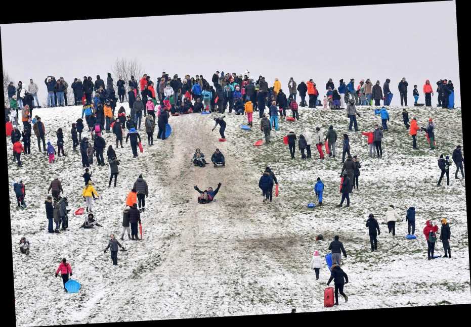
Crowds flocked to the capital's green spaces despite strict lockdown rules urging people to stay at home.
⚡ Read our UK weather live blog for the very latest news and forecasts.


Woolly-wearing Londoners were seen at Hampstead Heath, Primrose Hill, Richmond Park and other beauty spots in their droves.
Pictures show crowds of poeple congregating atop Primrose Hill, with thick, white flakes covering the ground.
Flakes fell across the rest of the UK today too, with a whiteout forecasted to grip the nation until at least Wednesday.
From mid-week next week, rainy weather is likely to drench the country and spark further flood misery.
There are currently six yellow weather warnings for snow and ice in place across the UK.


Four warnings for a combination of snow, frost and slippery ice are scattered across the UK.
A snow and ice warning is in place for the south west of England, including Plymouth but excluding Cornwall.
Another warning covers a huge chunk of the southeast including London, parts of Essex and Hertfordshire, Brighton and Kent, as well as eastern parts of Northern Ireland.
An ice warning is in place for the rest of Northern Ireland, including Derry.


Snow and ice is also forecast for the west and north of Scotland including parts of Glasgow.
The Midlands, most of Wales including Cardiff and parts of the south including Oxford and Bath are covered with a snow warning.
Brits flocked to beautyspots with packed scenes in London's Primrose Hill – depsite a strict stay at home message due to newly emerging Covid strains.
People were seen frolicking in big groups in the snow as London's green spaces were packed out.
Weather charts show temperatures plummeting to -2C in London and much of the South East throughout today.
Met Office chief forecaster Steve Willington said cold air from Iceland and the Arctic will bring with it "a mix of wintry hazards across the UK".
He said: "In clearer conditions, overnight ice will remain a hazard, while a band of snow is likely to bring falls of 1-3cm quite widely across central areas of the UK, particularly the Cotswolds and higher ground in the East Midlands on Sunday.


"But snow outside these areas is also a potential hazard."
According to the Met Office, a band of rain will cross the west of the south west of England on Sunday and turn to snow as it moves eastwards.
Up to 3cm of snow could settle, but areas of the country above 100m could see as much as 5-10cm. Dartmoor, the Brecon Beacons and Snowdonia could see as much as 15cm.
Meteorologist Simon Partridge said:"(The Midlands) is where we are going to see the snow lasting the longest.
"The band of snow that came through overnight stalled over the Midlands and will then track its way back over south-east England."
He added that more snow was expected across the southern half of the UK in the next few hours, with sleet and snow showers also forecast across northern Scotland.


Some parts of Northern Ireland have seen 7cmbut no more is likely to fall.
Mr Partridge said: "Our main focus is that it is going to be a really cold night, particularly across central and southern parts of the UK – so the whole of Northern Ireland, all of Wales, most of the southern half of England from the Midlands and southwards."
He added: "Temperatures are expected to dip to between minus 4C (24.8F) and minus 6C (21.2F) quite widely tonight and where we get that snow lying in parts of the Midlands we could see one or two places where temperatures are as low as minus 10C (14F)."
A widespread frost is expected, and conditions are expected to be hazardous including spots of ice on the roads.
Meanwhile, people are being urged to heed flood warnings into the weekend, with the Environment Secretary warning of the possibility of more "challenges" in parts of England due to wet weather next week.


The Met Office today urged people to take care in the perilous conditions.
In a tweet, a spokesperson said: "Many places are waking up to #snow and #ice this morning.
"Warnings have been updated so take care and stay #WeatherAware."
In a follow-up tweet, forecaster Rowan said: "A band of snow, sleet and rain are pushing east across the country today."
Social media was flooded with snaps of snowy gardens, frozen ponds and wintry woodland.
The hashtag "Narnia" was trending on social media as people shared images of their snowy neighbourhoods.
Mayor of London Sadiq Khan was also out enjoying the weather.


He posted a video of his family's golden retriever Luna spinning around the garden as the snow fell.
"Luna is loving the snow and hoping it settles," he said.
The Met Office put a yellow weather warning in place stretching from coast to coast in southern England and ending just below Manchester.
The public were warned to expect some icy patches on untreated roads and pavements, with journeys by road and rail likely to be affected.
Highways England warned that the snow had caused collisions on the M3, M27 and M25.
The agency urged drivers to only travel if absolutely necessary.
But Chris Tubbs, deputy chief forecaster at the Met Office, said wet weather is likely to return from the middle of next week.
He said: "Once the certainty increases about which areas are most likely to be affected by potentially heavy rain, we may need to issue further warnings, especially if next week's rainfall is likely to compound the impacts from this week."
It comes as two thousand homes in Didsbury, Greater Manchester, were evacuated and residents relocated to nearby leisure centres and hotels.
A massive sinkhole suddenly appeared in the road in Gorton, Manchester, bringing two homes crumbling to the ground.
And heavy rainfall prompted fears of a landslip in Slaithwaite, Yorkshire as a house was seen dangling on the edge of a bank on the River Colne.


Source: Read Full Article