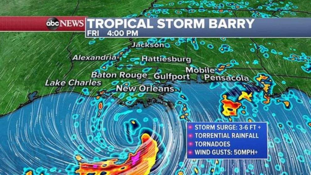
Tropical Storm Barry continues to slowly track north toward the Gulf Coast on Friday morning, bringing the potential for as much as 2 feet of rain in parts of Louisiana and disastrous flooding as a result.
The storm was moving west-northwest at just 5 mph with maximum sustained winds of 50 mph early Friday, but the storm is likely to strengthen throughout the day. Regardless of weather the storm manages to reach wind speeds of a low-end hurricane, the concern is for “long duration heavy rainfall” and “life-threatening storm surge” from the slow-moving system, according to the National Weather Service.
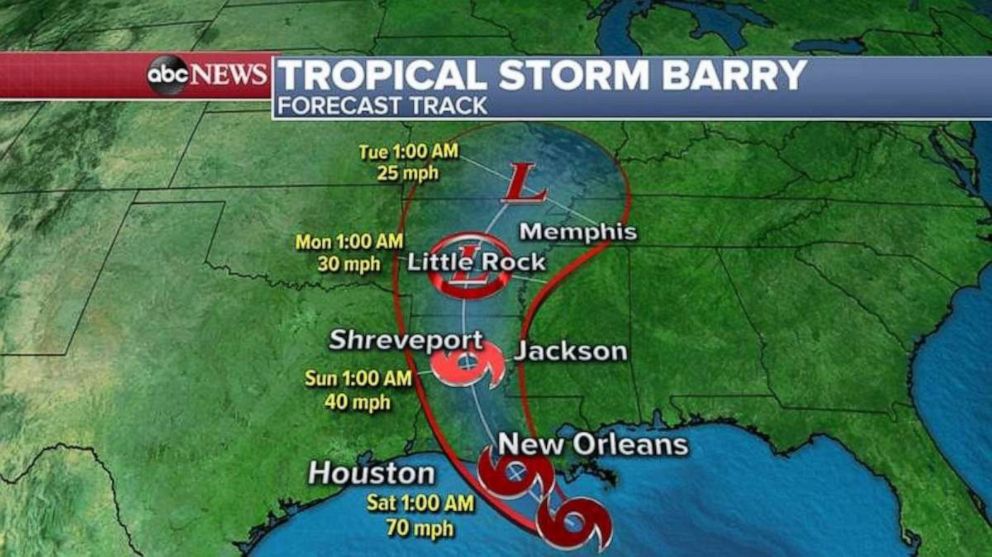
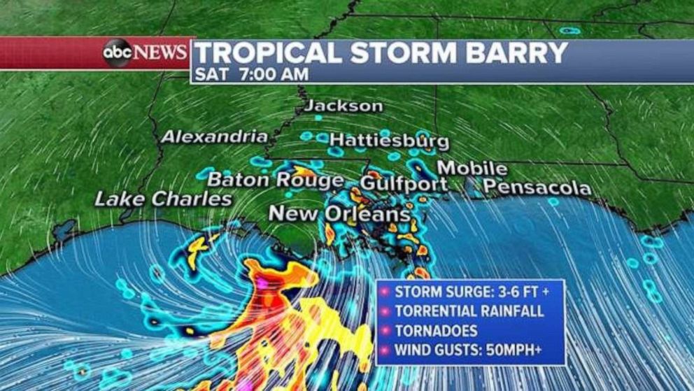
On the current track, Barry will make landfall along the Louisiana coast line sometime late Friday or early Saturday morning.
Hurricane warnings, tropical storm warnings, flash flood watches and tropical storm watches have been issued for parts of the Gulf Coast as Barry comes closer to the shoreline.
“We’re obviously in an all-hands-on-deck mode, and the preparations are not just in New Orleans but statewide,” Louisiana Gov. John Bel Edwards said Friday morning.
About 3,000 National Guards troops have been stationed across the state, as well as search-and-rescue teams with boats and hundreds of buses to transport those who are rescued to shelters in central Louisiana, Edwards added. A task force from Texas also has arrived to assist.
“We’re working extremely hard to make sure we’re as ready as possible,” Edwards said in an interview airing on “Good Morning America.” “You never know what Mother Nature’s going to throw at you.”
With parts of New Orleans already underwater from previous rainfall, this will be the first time a major tropical storm or hurricane has struck the state with the Mississippi River at a flood stage, which could be due to “climate change or climate disruption,” the governor added.
“This is not something we’ve had to deal with before,” he said. “This is a statewide effort, and we’re going to do everything we can to protect life and property.”
The White House officially issued an emergency declaration for Louisiana late Thursday, authorizing the Federal Emergency Management Agency to coordinate disaster relief efforts.
Trump himself tweeted, “Please be prepared, be careful & be SAFE!” to the residents of the state.
Tropical showers are expect to pick up in intensity across parts of the Gulf Coast Friday. Some of these tropical rain showers could have rainfall rates of 2 to 3 inches per hour, and could spawn tornadoes. The risk for tornadoes will increase during the evening hours as Barry comes closer to the shoreline — especially over southern Louisiana and parts of southern Mississippi.
Storms have already soaked parts of the coast. Downtown New Orleans received 6.27 inches of rain on Wednesday and much more is expected as the storm gets closer to shore.
The Mississippi River is expected to rise to about 19 feet on Saturday, according to the National Weather Service, which would test levees in New Orleans.
Towns along the coast are beginning to issue evacuation orders. Mandatory evacuations were issued for Grand Isle on Thursday, while a recommended evacuation order was given for Port Fourchon. Plaquemines Parish had already received evacuation orders on Wednesday.
Storm surge will begin to increase in parts of southern Louisiana throughout Friday, as winds begin to push water up against the shoreline. The surge will likely reach its maximum during the evening and overnight hours, and during the high tide cycles. Winds will increase in southern Louisiana throughout the day, occasionally gusting over 50 mph, which could cause scattered downed trees and power outages.
Landfall is only the beginning of the main impacts from this tropical system.
“There are three ways that Louisiana can flood: storm surge, high rivers and rain,” Edwards said on Thursday. “We’re going to have all three.”
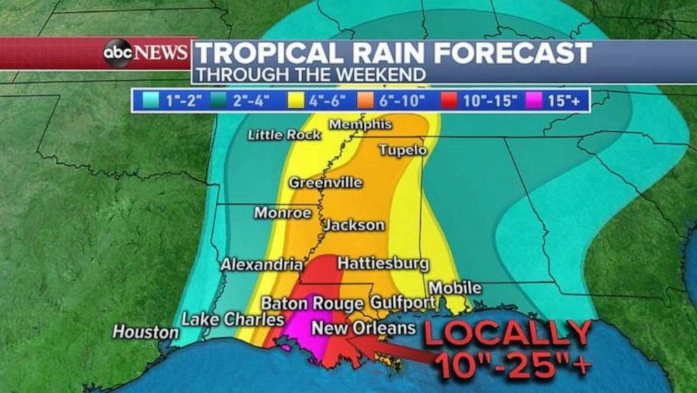
Barry will bring an onslaught of torrential rain leading up to, during, and after landfall. The heavy rain will fall directly east of the center of the storm. Rainfall rates of 2 to 3 inches per hour on Saturday will lead to widespread flash flooding.
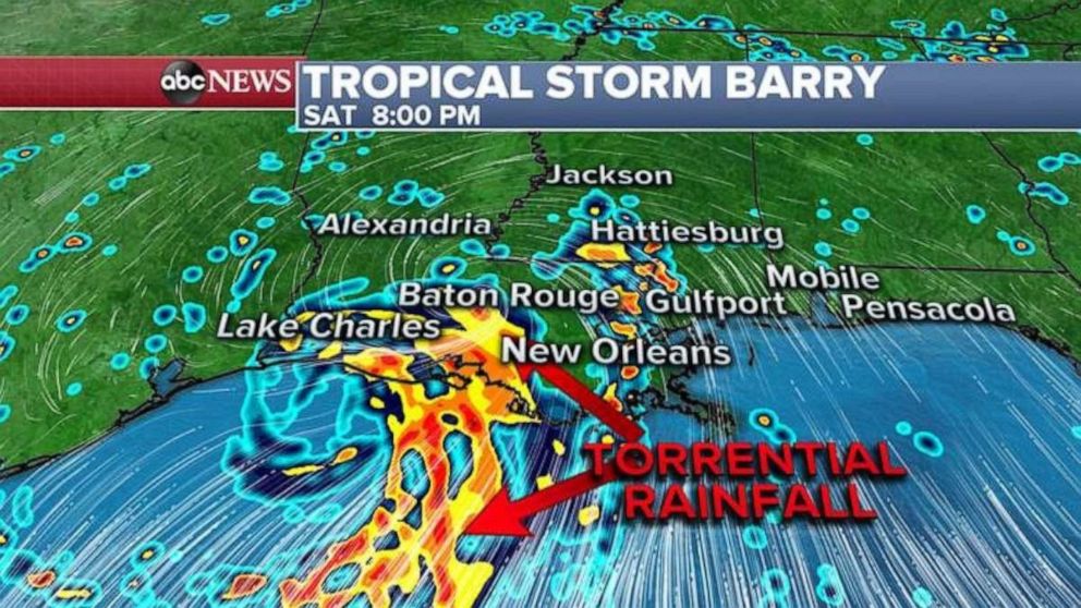
As much as 15 to 25 inches of rain is possible in the bands directly east of the center of the storm. This will lead to life-threatening and potentially disastrous flooding in parts of Louisiana.
Some of the heavy rain will also spread into parts of Arkansas and Mississippi late in the weekend and early next week.
Source: Read Full Article