Endeavour discovery: Expert discusses history of ship
We use your sign-up to provide content in ways you’ve consented to and to improve our understanding of you. This may include adverts from us and 3rd parties based on our understanding. You can unsubscribe at any time. More info
The map reportedly indicates that Mr Clark leveraged the US–Indian treaty to snatch land for settlers at the expense of the indigenous population. Historian Dr Robert Lee from Cambridge discovered this by studying the microfilm kept by the National Archives and Records Administration. The map is thought to have been filed under false authorship, and instead, it is now thought that Mr Clark himself drew it.
It depicts how 10.5 million acres of land across the states was taken from the natives, including the territories of Sauk, Meskwaki, and Iowa.
This was done right after the War of 1812 and it asserted by proclamation that the US had purchased the area the size of Switzerland from the Osages by treaty in 1808.
But this appeared to violate a treaty signed with the British.
This was called the Treaty of Ghent with Great Britain.
Mr Clarke reportedly redrew an Indian treaty line which added millions of acres to the US public domain.


It was then filed in the secret in the war’s correspondence archive under Captain Eli B. Clemson’s authorship.
It goes against the idea promoted by Mr Clark, in that he claimed he had clarified an old boundary and not one manufactured himself.
Dr Lee said: “This astonishing map shows how William Clark leveraged the US-Indian treaty system to promote settler supremacy in the US at a time when he’s been praised for trying to protect Indigenous land from squatters.
“Now we can see just how scheming and disingenuous he really was.”
It goes against the idea Mr Clark had claimed, in that he carefully he had clarified an old boundary and not one manufactured by himself.

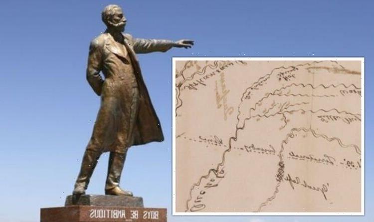
The map was unsigned and undated.
It had been sketched in pencil and ink and contained about 50 named features.
These include boundaries, towns and rivers.
It also depicted around 150 unnamed features which were mostly unidentified settlements.
And Dr Lee also explained why the number of the landmarks are evidence that Captain Clemson did not sketch the map.
DON’T MISS
Black hole warning as rogue body spotted wandering wandering Milky Way [REVEAL]
Biden makes move as Putin warned he risks losing ‘cash cow’ [INSIGHT]
Archaeologists left horrified by grim Roman-era burial [REPORT]

Dr Lee said these features seemed to match some features described in a letter written by Clark in September 1816.
He said: “The most revealing feature is a line between the Arkansas and Red Rivers, which Clark described in the 1816 letter that accompanied the map before the two got separated.”
He added that this proved that Mr Clark “personally orchestrated the little-known scheme to steal half of what is today the state of Missouri from its indigenous owners.”
Dr Lee added: ”’This stray line looks like the cartographic equivalent of a Freudian slip.
“A naïve interpretation might say he found a huge loophole in the Treaty of Ghent. A realistic one would say he broke it to seize a landmass triple the size of Connecticut.”

And this was not the only instance of Mr Clark snatching up land.
In fact, it is thought that he was associated with the grabbing of up to a staggering 419 million acres of indigenous land.
That is more than a third of the dominion that the US had claimed at the time of his death in 1838.
Other manuscripts found since Mr Clark’s death have turned up in unlikely places.
These include a pile of rubbish in Kansas, an apartment in New York City, and a basement in Washington, DC.
The last original maps came to light after private papers were found in Saint Paul in 1953.
Source: Read Full Article