MORE ice and sleet is set to blast Britain in the coming days after flash floods and almost a foot of snow hit today.
Yellow weather warnings are now in place until the weekend after plummeting temperatures sparked travel chaos up and down the country.
⚠️ Read our UK weather live blog for the very latest news and forecasts.


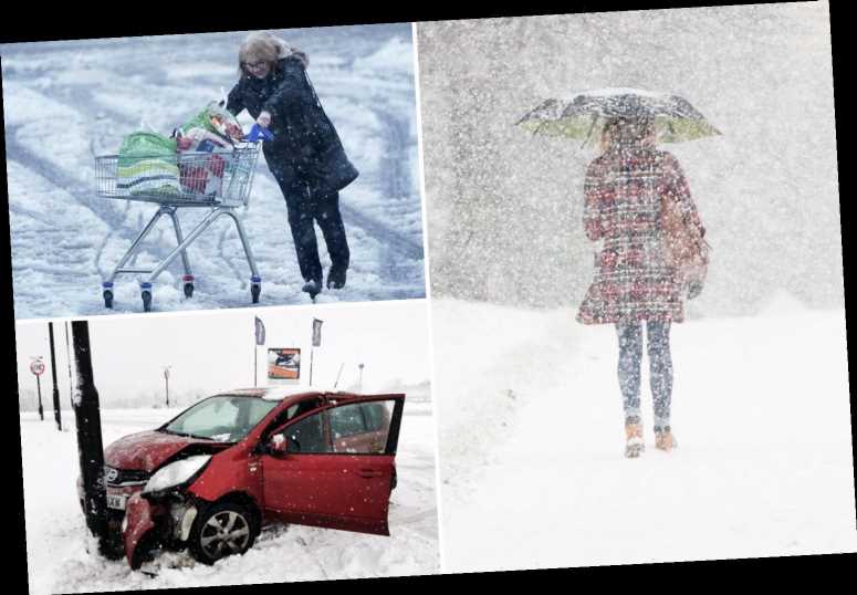
The whiteout caused travel mayhem today, leaving drivers trudging through the ice while others were stranded.
And a major incident was declared by the Yorkshire Ambulance Service after heavy snow and a surge in patient demand hit hard.
Meanwhile, early risers were seen scooping snow from their driveways in County Durham this morning, as drivers battled to steer through the white stuff in Northumberland and Yorkshire.
In Leicester and Essex, cars faced a different struggle, making their way through floodwater after heavy rain fell in parts of the country overnight.
One driver suffered the worst of the treacherous conditions, their car pictured smashed up against a tree in Leeds.
And terrifying footage showed a bus spinning down a hill in Halifax, West Yorks.
Another motorist careered out of control in Huddersfield, sliding down a hill before crashing into another car.
ICE BLAST
Met Office recordings showed 11cm of snow falling in Strathallan, Scotland, today, while parts of Northumberland saw 10cm of the white stuff.
Albemarle in West Yorks., recorded 9cm, although the figures off record could be much higher.
“Looking at people’s pictures from today, it could be 15cm,” Met Office forecaster Greg Dewhurst told the Sun Online.
"The heaviest snowfall has passed now and it will gradually ease as we go through to this evening. But it wouldn't surprise me if a couple more places see another 2-5cm."
Up to 30cm of snow was expected to fall on Wednesday evening through to Thursday in Scotland, while parts of northern England could see around 20cm.
The Met Office issued an amber snow warning for these areas yesterday, with forecasters warning that some roads may be badly affected.
The alert was changed to a yellow weather warning for snow and ice this morning, and has been extended until 10am on Friday.
A separate warning is in place on Saturday, with northern England and Scotland at risk of snow and ice.
Temperatures as low as -7C blasted the east of England while Scotland was set to plunge as low -12C.


The temperature fell as low as minus 5.5C in North Yorkshire on Thursday morning, and minus 6.4C in Dalwhinnie in the Highlands.
Nicky Maxey, a Met Office spokeswoman, said on Thursday that unsettled conditions are set to last into next week, and she urged people to be alert for new warnings from the forecaster.
She said: "We've seen snow leave the M62 Yorkshire area and journeying now into the Vales or Yorkshire.
"It will push further south as we go through the day, likely to go down to the Midlands but becoming less intense.
And the freezing temperatures are likely to last, with the Met Office warning of further snow and ice on Saturday.
They say heavier snowfall is more likely above 200m in Scotland and northern England, where 5-10 cm of snow may accumulate, possibly 20 cm on highest routes.
The rest of England will see heavy rainfall, particularly in London and the South East, while Wales and Northern Ireland are predicted to stay mostly dry.
Dismissing another Beast from the East, Met Office forecaster John Griffiths, said: "On Thursday a band of rain, sleet and snow will hit parts of Scotland and northern England, which will slowly extend south to the Midlands as the day progresses.
"It is expected to be very cold in these areas, dropping below 0C in Scotland and parts of northern England.
"This will start to gradually ease and die out during the evening, with frost and freezing fog coming in."
Meanwhile, forecaster Matthew Box said: "The snow will continue throughout the day. It'll peter out in places as it moves south.
"By the afternoon we'll see sleet and snow across the Midlands, parts of Wales and even further south.”
There will be some respite tomorrow before more snow grips the northern half of the country over the weekend.


The frosty outlook has led to increasing fears of another Beast from the East terrorising the country by the end of the month.
Sudden Stratospheric Warming (SSW) – the weather event which led to 2018's devastating Beast – took place in the atmosphere last week.
It could be two weeks before the impact of the SSW is felt at ground level but forecasters at the Met Office say it has "increased the chances”.
SSW effectively reverses Britain's wind pattern.
Instead of drawing wind in from the warm west, it switches to haul bitterly cold gusts from Siberia in the east.
Although the weather event has taken place its impact will not be known for at least a week, according to the Met Office.
In 2018 the Beast sparked the worst snowstorms for decades, with 20in falling.
Hundreds of schools shut, the military mobilised to help the NHS and there were fears the nation could run out of gas.
Paul Davies, the Met Office’s Chief Meteorologist, said: "We can’t completely rule out a signal for colder weather following this SSW event later in the month."


Meteorologists have confirmed a sudden stratospheric warming (SSW) event is happening over the Arctic, which is what happened before the Beast from the East three years ago.
When this happens the warming can affect the jet stream which regulates much of the weather in the UK.
If heavily disrupted, or even reversed, Brits could be hit with the same chilly conditions currently north of Scandinavia.

The Met Office's long-range forecast predicts "significant snowfall on the boundary between milder and colder air masses" as we go into February.
The last Siberian weather front to be given the nickname hit in 2018 when snow blanketed large parts of Britain and temperatures plummeted to -10C.
Met Office forecaster Craig Snell said: "The stratosphere above the North Pole has warmed, it started its process on the 4th of January and has been rapidly warming over the last few days."

Source: Read Full Article