BRITAIN is set to be hit with a fortnight of thundery downpours and floods as the weekend’s balmy weather fades away.
Temperatures are likely to remain high, but we could soon see monsoon-style wet weather after the sunniest Spring on record.


While many Brits have enjoyed blue skies over this weekend, showers and thundery downpours will cover the country over the next two weeks.
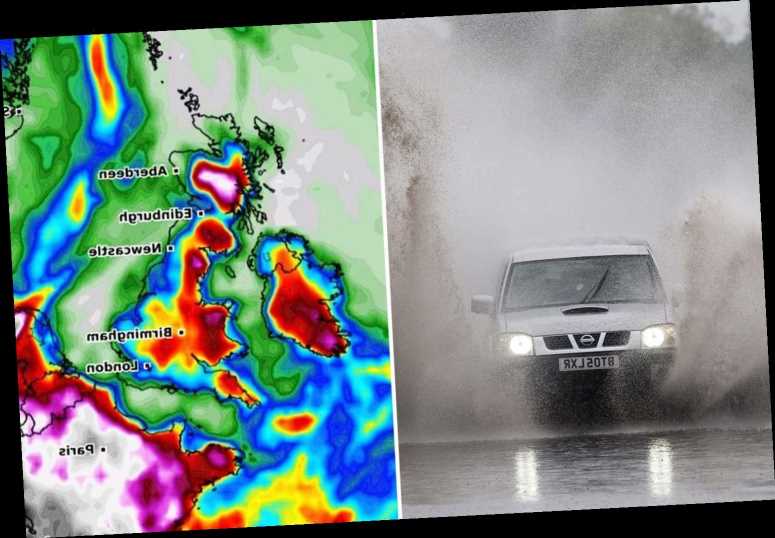
As temperatures stay high, the wet weather will be even heavier – with Scotland, Wales and the north west of England among the worst hit areas.
Western Scotland, including Glasgow, could see up to four inches of rain, while Liverpool, Manchester and northern Wales could see between two and three inches.
The UK's Environment Agency has warned that some areas could see flooding, saying: “Local flooding from surface water is possible until Wednesday for parts of England and Wales. Land, roads and some properties may flood and there may be travel disruption.”
WARM EVENING
This evening will see balmy temperatures across most of the country, with the mercury hitting 23C in Cambridge, 22C in Leeds and 20C in Cardiff.
The warm weather will continue into Monday, with Nottingham enjoying temperatures of 23C, Carlisle of 21C and Southampton of 20C by the afternoon.


Met Office forecaster Matthew Box said the beginning of next week will see warm temperatures continue while thundery showers pick up.
He said: “Through much of this week – particularly through to Wednesday – we’re still expecting there to be this mix of sunny spells and heavy thundery downpours here and there.”
For the last full week of June, it does look like we could see some fairly unsettled weather with showers or longer spells of rain.
The heavy showers will continue into the end of next week, with temperatures beginning to drop in the east of England – in places like Norwich and Hull.
Brian Gaze, founder of forecaster The Weather Outlook, told Blowing Hot and Cold videochat that “June looks more flaming wet than flaming hot this year.”
He added: “The 'European monsoon' is seeing westerly winds return, bringing rain, after being absent for much of a very dry spring.”
'THUNDERY DOWNPOURS'
The Met Office's Dr Box said that next weekend will see "quite mixed" weather, but heavy rain in some places.
He said: “As we head towards next weekend, it does look like it’s going to be quite mixed, changeable, but showery conditions are likely to continue.
“But, again we’re going to see some sunny spells as well. The showers could be heavy in places.”

During the last week of June, however, the weather will take a turn for the worse – the Met Office meteorologist says it could become more “unsettled” with thundery downpours likely.
Dr Box said: “And then, for the last full week of June, it does look like we could see some fairly unsettled weather with showers or longer spells of rain, with southern areas of the UK seeing some heavy spells of rain, possibly thundery as well.
The downpours are likely to be heavier in summer months like June, because the warm weather creates more moisture in the air.
Dr Box explained: “The heavier showers can be heavier in summer because of the preponderance of warmer air that’s available – moisture that’s available.
“You need that moisture content to give the really heavy downpours, and that’s more readily available in summer when the air is warmer.
“You can get heavy showers in the other months as well – but we all experience those more frequent thundery downpours through the summer months if we get the right conditions because of the availability of warm air.”


Source: Read Full Article