BRITAIN is being slammed by 27 hours of intense rain and gales – and the remains of Hurricane Humberto will bring further misery this week.
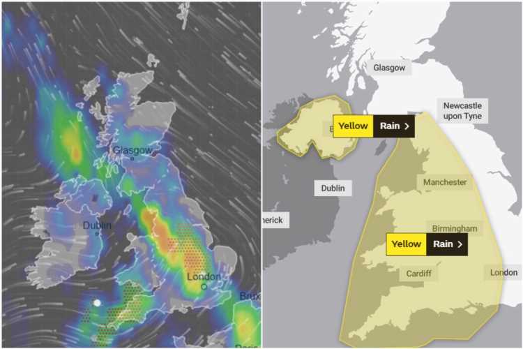
Met Office forecasters have issued yellow weather warnings for the entire western half of the UK as 40mm downpours sweep in today.


Flash floods and intense thunderstorms are predicted in the affected areas – stretching from Cornwall up to Cumbria and Northern Ireland.
In England and Wales, the danger-to-life weather warning will be in place until 6pm tonight as the autumnal drenching strikes.
In Northern Ireland, more dramatic thunderstorms and flooding is predicted until as late as 9pm, forecasters say.
The Met Office said last night: "Heavy showers and thunderstorms are expected on Saturday evening, perhaps merging into longer spells of rain on Sunday.
SPONSORED CONTENT: How to save £219 a year off your energy bills
BEAT energy price rises year after year with Switchcraft. It's free and it could save you an average of £219 a year.
- Sign up, easily compare tariffs and switch
- Once you sign up, Switchcraft will automatically find you a cheaper deal when a better tariff comes up, saving you time, hassle and money.
- It takes just 3 minutes. That's it!
- Get £5 cashback and never worry about switching again
- Click here to get saving!
News UK has a brand partnership with Switchcraft. The £5 will be paid into your bank account within four months of completing the switch. Prepayment meter customer customers will receive a £5 Amazon voucher. Open to those 18 and over. UK residents only. Click here for full T&Cs.
"While many places are likely to stay dry, there is a risk of 30-40mm in a few hours which may lead to localised flooding and travel disruption.
"Strong, gusty winds are also likely at first.
"During Sunday, the showers are likely to merge into a longer period of rain.
"This perhaps heaviest over the south and west of Northern Ireland, with the potential for a further 30-40mm in 3-6 hours in a few places."
HUMBERTO HITS
It added: "The rain will clear away northeastwards during the afternoon.
"But it will be followed by heavy showers or thunderstorms in southwest England and perhaps Wales, which could give a further 20-30mm in 1-2 hours."
And there will be little rest from the horrible weather before the remnants of Hurricane Humberto strike on Monday into Tuesday.
The first wave of rain from the weather system – currently in the Atlantic – will batter the western half of the UK on Monday evening.
But the full brunt of the ex-Hurricane will smash huge swathes of the country with showers and gales.
A week off cooler temperatures will also send Brits reaching for the thermostat.
A spokesman for The Weather Company added: “Particularly wet and windy weather is expected to start next week as the remnants of Hurricane Humberto are expected to pass to the north-west of Britain."


Source: Read Full Article