Tornadoes, one might think, should be easy to spot. They reach down like gnarled fingers in the heat of storms, ripping trees from the ground and blowing cars off the road, picking up Kansas farmhouses and transporting them to the land of Oz.
But things are not so simple in Canada, or in any region with a low population density. Canada is vast — it is the world’s the second-largest country by landmass, after Russia — but most of its residents live near the United States border. As a result, many Canadian tornadoes end up touching down in areas with no witnesses, leaving the country’s twister census remarkably incomplete.
Until just a couple of years ago, the average number of confirmed Canadian tornadoes per year was around 60, (enough to earn its spot as the country with the second most tornadoes in the world, behind the United States, which averages around 800 annually) although scientists calculated that the actual number should be closer to 150.
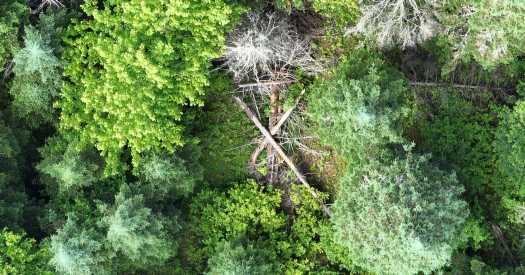
Such a dearth of data is both unsatisfying and dangerous. Tornadoes can be deadly and their property toll costly. Their frequency, location and severity is not always well understood, and may also be changing. “If we’re ever going to pin down how climate change is affecting this stuff for real, we need accurate quantification — not only of how many tornadoes happen, but where,” said Ian Giammanco, a meteorologist at the Insurance Institute for Business & Home Safety. He added that knowledge of tornado trends could help warn people of future storms and guide building and infrastructure codes. Recently, a group of meteorologists and weather scientists with the Northern Tornadoes Project at Western University in London, Ontario, have been seeking to address this deficiency. Using social media and eyewitness reports, satellite imagery, drone footage and fallen trees, the group has tracked more Canadian tornadoes than ever before. In 2021, a record was set for the most confirmed tornadoes in a year: 117. In 2022, that record was tied; 80 of those tornadoes were verified solely by the Northern Tornadoes Project. So drastic an increase probably does not reflect an upward trend in the number of Canadian tornadoes, scientists said, but the added scrutiny they are receiving. “We’re just putting so much more effort into finding these things,” said David Sills, a weather scientist and director of the group. “We’re trying to have an impact.” The first step of tornado detective work is to figure out where to look. Tornadoes form when cold air pushes down against rising hot air under the right conditions. This can happen in many different kinds of storms, although the largest and most destructive tornadoes come from the mesocyclones of supercells: tall columns of rotating updrafts in large thunderstorms. Precipitation in the storm cloud pushes the mesocyclone down, and as parts of it are pressurized and exposed to different temperatures, a funnel is created. When this funnel touches the ground, it is classified as a tornado. The tornado recipe is more likely to work in places where there is a consistent supply of both cold air (often from the mountains) and hot air (often from the tropics). A classic example unfolds in the Great Plains of the United States, where moist, warm air from the Gulf of Mexico meets cold, dry air from the Rockies. More tornadoes occur there than in any other place on Earth. In Canada, the majority of tornadoes pop up in Alberta, Saskatchewan and Manitoba — the so-called Prairie Provinces — and Ontario. Scientists with the Northern Tornadoes Project keep one eye on the weather radar in those regions and another on social media, looking for reports of strange weather events. A lot of the work, then, is retrospective, using evidence on the ground to reconstruct a storm after it passes. What were the wind speeds? What path did the storm take? Tornadoes are often confused with downbursts, columns of wind that push onto the ground and spread out radially. Downbursts can precede tornadoes, and they form under similar weather conditions, but typically cause much less damage; confusing one for the other can skew data. Satellite imagery sometimes doesn’t help in these instances; a single pixel in a satellite image corresponds to nine square feet of land — sufficient resolution to determine only that some sort of high-speed wind event passed through the area. “You have to get an aircraft or a drone out there,” said Connell Miller, a weather scientist with the Northern Tornadoes Project. This is the key step for tornado detectives. Dr. Miller said that the specifics of each storm came out in the high-resolution photographs captured by drones and planes. Trees falling in on each other indicate a tornado, whereas trees falling in the same direction indicate a downburst. A long, thin destruction path: tornado. A wide destruction path: downburst. Two parallel paths? A multiple-vortex tornado. Shingles torn off barns, crops ripped out of the ground, signs blown into forests — all this information helps scientists reconstruct the tornado, understanding how it formed and what kind of risk it posed, or would pose, to people and infrastructure. Dr. Sills said that, even in unpopulated areas, tornadoes could destroy electrical lines and start wildfires, so their impact is palpable. But the primary goal is preventive. “People want to build up the resiliency of their communities,” he said. Better research manifests in revised building codes and warning systems — every storm counts. Source: Read Full Article


