Rescue crews searched desperately Sunday amid shattered homes and tangled debris for dozens of people still missing after record-breaking rain sent floodwaters surging through Middle Tennessee.
At least 22 people were killed and more than 50 were still missing as of Sunday afternoon, according to Humphreys County public information officer Grey Collier. Authorities feared the death toll could rise.
The flooding in rural areas took out roads, cellphone towers and telephone lines, leaving families uncertain about whether their loved ones survived the unprecedented deluge. Emergency workers were searching door to door, said Kristi Brown, a coordinator for health and safety supervisor with Humphreys County Schools.
Humphreys County Sheriff Chris Davis said many of the missing live in the neighborhoods where the water rose the fastest. Their names were on a board in the county’s emergency center.
Up to 17 inches of rain fell in the county in less than 24 hours Saturday, appearing to shatter the Tennessee record for one-day rainfall by more than 3 inches, the National Weather Service said.
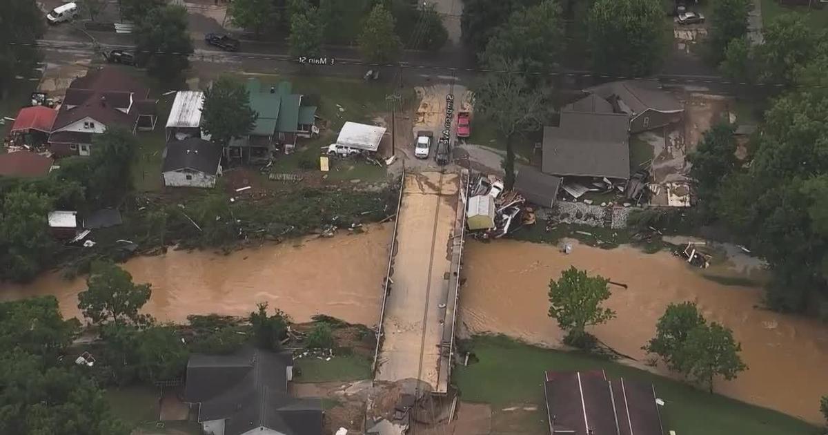
Tennessee Governor Bill Lee toured the area, stopping on Main Street in Waverly where some homes were washed off their foundations and people were sifting though their water-logged possessions.
Shirley Foster cried as the governor walked up. She said she just learned a friend from her church was dead.
“I thought I was over the shock of all this. I’m just tore up over my friend. My house is nothing, but my friend is gone,” Foster told the governor.
The hardest-hit areas saw double the rain that area of Middle Tennessee had in the previous worst-case scenario for flooding, meteorologists said. Lines of storms moved over the area for hours, wringing out a record amount of moisture — a scenario scientists have warned may be more common because of global warming.
The downpours rapidly turned the creeks that run behind backyards and through downtown Waverly into raging rapids. Business owner Kansas Klein stood on a bridge Saturday in the town of 4,500 people and saw two girls who were holding on to a puppy and clinging to a wooden board sweep past, the current too fast for anyone to grab them.
He isn’t sure what happened to them. Klein heard that a girl and a puppy had been rescued downstream, and that another girl was also saved, but he wasn’t sure it was them.
By Sunday, the floodwaters were gone, leaving behind debris from wrecked cars, demolished businesses and homes and a chaotic, tangled mix of the things inside.
“It was amazing how quick it came and how quick it left,” Klein said.
The Humphrey County Sheriff Office Facebook page filled with people looking for missing friends and family. GoFundMe pages were made asking for help for funeral expenses for the dead, including 7-month-old twins yanked from their father’s arms as they tried to escape.
Not far from the bridge, Klein told The Associated Press by phone that dozens of buildings in a low-income housing area known as Brookside appeared to have borne the brunt of the flash flood from Trent Creek.
“It was devastating: buildings were knocked down, half of them were destroyed,” Klein said. “People were pulling out bodies of people who had drowned and didn’t make it out.”
At the Cash Saver grocery in in Waverly, employees stood on desks, registers and a flower rack as the waters from the creek that’s usually 400 feet from the store rushed in after devastating the low income housing next door. At one point, they tried to break through the celling into the attic and couldn’t, store co-owner David Hensley said.
The flood waters stopped rising as fast just as the situation was getting dire and a rescue boat came by. “We told him that if there’s somebody else out there you can get, go get them, we think we’re OK,” Hensley said.
Just to the east of Waverly, the town of McEwen was pummeled Saturday with 17.02 inches (43.2 centimeters) of rain, smashing the state’s 24-hour record of 13.6 inches from 1982, according to the National Weather Service in Nashville, though Saturday’s numbers would have to be confirmed.
A flash flood watch was issued for the area before the rain started, with forecasters saying 4 to 6 inches of rain was possible. The worst storm recorded in this area of Middle Tennessee only dropped 9 inches of rain, said Krissy Hurley, a weather service meteorologist in Nashville.
“Forecasting almost a record is something we don’t do very often,” Hurley said. “Double the amount we’ve ever seen was almost unfathomable.”
Recent scientific research has determined that extreme rain events will become more frequent because of man-made climate change. Hurley said it is impossible to know its exact role in Saturday’s flood, but noted in the past year her office dealt with floods that used to be expected maybe once every 100 years in September south of Nashville and in March closer to the city.
“We had an incredible amount of water in the atmosphere,” Hurley said of Saturday’s flooding. “Thunderstorms developed and moved across the same area over and over and over.”
The problem isn’t limited to Tennessee. A federal study found man-made climate change doubles the chances of the types of heavy downpours that in August 2016 dumped 26 inches of rain around Baton Rouge, Louisiana. Those floods killed at least 13 people and damaged 150,000 homes.
Source: Read Full Article