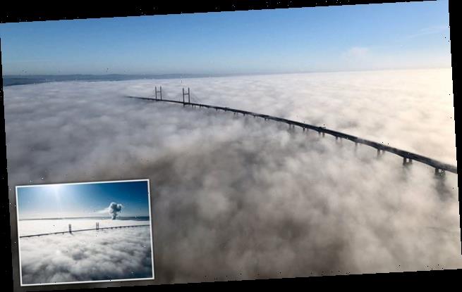
Amazing aerial photographs show the Severn Bridge draped in a spectacular sunlit blanket of fog
- The photos were taken early on Tuesday by the South West branch of the National Police Air Service
- Stunning weather conditions were caused by a weather phenomenon where the temperature drops
- Sunshine beams down onto the fog below which completely covers the whole area as well as the bridge
Amazing aerial photographs have been taken which show the Severn Bridge draped in a spectacular sunlit blanket of fog caused by a weather phenomenon known as a temperature inversion.
The photos of the Severn Estuary that separates England and Wales were taken by the South West branch of the National Police Air Service early on Tuesday.
The breath taking sight was caused by a weather phenomenon known as a temperature inversion, this occurs when the lowest part of our atmosphere, known as the troposphere typically sees air temperatures drop in its higher elevations.
This is the reason that a mountain top is typically colder than the air at its base.
Stunning aerial shots (as above) show the Severn crossing covered in fog on Tuesday morning. The photos of the Severn Estuary that separates England and Wales were taken by the South West branch of the National Police Air Service
The fog completely covered the Prince of Wales bridge which carries the M4 motorway between England and Wales
But a temperature inversion occurs when cold air instead gets trapped beneath warm air in the troposphere, acting like a lid for clouds.
According to the Met Office: ‘This often happens in areas of high pressure, where the air high up often sinks towards the ground.
What is a temperature inversion?
According to the Met Office temperature inversion often happen in winter when mist and fog get trapped.
The lowest part of our atmosphere is the troposphere, which can extend to heights of 16 km and is where most of our weather happens.
It is also a section of the atmosphere where the temperature typically gets lower the higher up you go, for example, when you climb a mountain it is often colder at the top. However, sometimes a small layer can form where the temperature increases with height. This layer is called an inversion.
This often happens in areas of high pressure, where the air high up often sinks towards the ground. As it falls, it dries out and warms up. This warm layer of air can act as a lid and trap cooler air near the surface (this is because warm air is more buoyant than cold air, and so it will tend to ‘float’ above the colder air, trapping it).
This gives us the inversion, because if you were now to climb the mountain, it would get warmer as you got to the top. This is inverted compared to what you would normally expect, hence the term ‘inversion’.
Inversions are most common in winter when mist and fog become trapped in the cooler air low down, but inversions can happen all year round.
Source: The Met Office
‘As it falls, it dries out and warms up. This warm layer of air can act as a lid and trap cooler air near the surface.
‘This is because warm air is more buoyant than cold air, and so it will tend to ‘float’ above the colder air, trapping it.
‘This gives us the inversion, because if you were now to climb the mountain, it would get warmer as you got to the top.
‘This is inverted compared to what you would normally expect, hence the term ‘inversion’.’
Though the phenomenon can happen all year round, it’s most likely to occur during the winter.
It comes as a temperature inversion was also spotted in the Isle on Wight yesterday.
Another phenomenon could happen again this evening as fog is also expected in some places this evening.
Most places across the UK will remain dry and cloudy today.
There will be a few clear intervals tonight which could lead to isolated fog and frost.
Cloudy weather will prevail across most parts tomorrow.
This is while weather over the weekend.
Friday will be breezier and cloudier further north. Showers will follow across the weekend and Sunday will see wintry conditions for northern areas.
Source: Read Full Article


