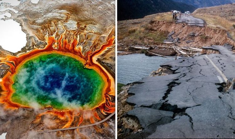
The Yellowstone caldera gets its chilling nickname as a supervolcano due to its ability to inflict devastation on a global level. Located below the states of Wyoming, Montana and Idaho, the supervolcano is constantly monitored by the USGS (United States Geological Survey) for signs that a supereruption is on its way. One of the key things researchers look out for is earthquake swarms in the area, due to fears they could trigger an eruption.
In the month of July, there were 135 earthquakes in the Yellowstone region, including a swarm of 78 located tremors.
The largest earthquake of the month was a 2.9 magnitude, which was not reported by anyone inside the park at the time.
However, these natural events can be much more dangerous if they occur on a larger scale, and researchers are more than aware of it.
USGS scientist Mike Poland revealed in his monthly update how things were much different 60 years ago.
It was frightening
Joann Smith
He said: “August is an important anniversary for Yellowstone.
“60 years ago, the 1959 Hebgen Lake earthquake occurred on August 17 at 11:37 at night.
“Here’s a picture of the fault scarp that formed during that earthquake.
“In fact, you can still visit that fault scarp today.
“I think this anniversary is a good reminder to us that earthquake hazards in the Yellowstone region are pretty significant.
JUST IN: How engulfing spacetime was found lurking in Milky Way’s heart
“Magnitude six and seven events do happen and that’s something we all need to be aware of.”
The quake caused massive damage, including 28 fatalities and a considerable £9million in repairs to highways and timbers.
Joann Smith, who was 11 years old at the time of the disaster, recalled the horror of the event in 2009.
She said: “It was frightening, it was horrible.
DON’T MISS
Yellowstone volcano: How USGS study showed ‘abnormal’ change [REVEALED]
Yellowstone: How scientists made alarming find in lake [COMMENT]
Yellowstone volcano shock: Eruption mantle runs under California [STUDY]
“You could actually see the ground open up.”
The event caused a massive avalanche of rock, soil and trees, which descended down from the Madison River Canyon’s south wall at nearly 100 mph.
It took less than one minute for the 80 million tonnes of rock to slam into the narrow canyon, blocking the river and creating the lake.
The fallen material formed a wall blocking the Madison River’s flow.
After only three weeks the damned river created a lake more than 170 feet deep.
The lake the quake created now covers an area five miles long and a third of a mile wide.
Today, tourists to the area can stop by the Earthquake Lake Visitor Centre, which is situated 27 miles north of West Yellowstone to re-live the horrors from more than half a century ago.
Source: Read Full Article


