Extreme blasts of cold weather hitting Europe and the USA are NOT caused by a warming Arctic changing the way the jet stream moves
- Previously it was thought a warming arctic was changing the jet stream waves
- The new research found fluctuations in the jet stream may be warming the arctic
- They found that any link between the two was over years not a longer period
Extreme blasts of freezing weather hitting Europe and the USA in recent years aren’t caused by a warming Arctic changing the jet stream, as previously thought.
Research by the University of Exeter disputes earlier studies suggesting a warming Arctic was creating a ‘wavier’ jet stream and linked to climate change.
They found it’s more likely the other way around with random fluctuations in the jet stream warming up the Arctic over decades.
Scroll down for video
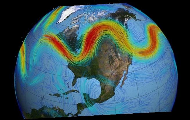
The new study shows Arctic warming does not drive a more meandering jet stream but changes in the jet stream may be contributing to a warming Arctic
The jet stream is a band of strong winds between five and seven miles above the Earth blowing from the west to the east.
While there is evidence of a link between the Arctic warming, climate change and a wavier jet stream over the short term – it doesn’t apply long term.
It was assumed there was a long term trend towards a wavier stream that was causing extreme weather conditions to strike mainland Europe and the USA.
Dr Russell Blackport, a research fellow in mathematics and lead author of the study, said there does appear to be a link between the two.
He said a wavier jet stream did seem to have some link to arctic warming on a year-to-year or decade-to-decade basis – but not long term, suggesting it was not the cause of the warming Arctic or cold bursts in Europe and the USA.
For about two decades, the jet stream was observed to have a wavier flow.
In this study, published in Science Advances, Dr Blackport and his team studied climate model simulations and observations of conditions going back 40 years.
They found that the previously reported trend towards a wavier circulation during autumn and winter has reversed in recent years.
The team say this is despite continued Arctic warming, further suggesting that the two are not linked.
Previously studies suggesting a link between freezing temperatures and cold episodes hitting Europe and the US were linked to changes in the jet stream from a warming Arctic – but Exeter researchers say this isn’t the case
There are ‘no long-term trends in waviness’, said Blackport, who said his findings were backed up by climate model simulations showing little change in the stream.
Professor Screen, an associate professor in climate science at Exeter, said the idea of a link just doesn’t hold up to any kind of scrutiny over a longer period.
‘With the benefit of 10 more years of data and model experiments, we find no evidence of long-term changes in waviness despite on-going Arctic warming.’
The research has been published int he journal Science Advances.
WHAT IS A JET STREAM?
Jet streams are fast flowing, narrow currents of air that carry warm and cold air across the planet, much like the currents of a river.
They cover thousands of miles as they meander near the tropopause layer of our atmosphere.
They are found in the atmosphere’s upper levels and are narrow bands of wind that blow west to east.
The strongest jet streams are the polar jets, found 30,000 to 39,000 ft (5.7 to 7.4 miles/ 9 to 12 km) above sea level at the north and south pole.
In the case of the Arctic polar jet this fast moving band of air sits between the cold Arctic air to the north and the warm, tropical air to the south.
When uneven masses of hot and cold meet, the resulting pressure difference causes winds to form.
During winter, the jet stream tends to be at its strongest because of the marked temperature contrast between the warm and cold air.
The bigger the temperature difference between the Arctic and tropical air mass, the stronger the winds of the jet stream become.
Sometimes the flow changes direction and goes north and south.
Jet streams are strongest – in both the southern and northern hemispheres – during winters.
This is because boundaries between cold and hot air are the most pronounced during the winter, according to the National Weather Service (NWS).
The direction the air travels is linked to its momentum as it pushes away from the earth’s equator.
‘The reason has to do with momentum and how fast a location on or above the earth moves relative to earth’s axis,’ NWS explains.
The complex interactions of many factors, including low and high pressure systems, seasonal changes and cold and warm air – affect jet streams.
Source: Read Full Article


